
Tinker’s Creek is named for Joseph Tinker, the principal boatman for Moses Cleaveland’s 1796 survey crew. Tinker died in a boating accident on the crew’s return trip to New England, but his name lives on through one of Northeast Ohio’s most remarkable waterways.
Today, Tinker’s Creek is the largest tributary of the Cuyahoga River, draining portions of 24 jurisdictions across Portage, Geauga, Summit, and Cuyahoga counties. The watershed covers 96.4 square miles, and the creek flows approximately 30 miles before joining the Cuyahoga River at river mile 16.36.
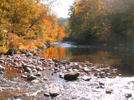
One of the creek’s defining features is the dramatic Tinker’s Creek Gorge, now protected within the Cleveland Metroparks Bedford Reservation. The gorge’s steep, rocky terrain historically made the creek corridor difficult to develop for farming or housing, which helped preserve this area as a natural landscape. The gorge is recognized nationally as a National Natural Landmark, with sections of bedrock stream channel and waterfalls that shape habitat and act as natural barriers to fish passage.
The Tinker’s Creek watershed lies on a glaciated plateau characterized by silt loam and clayey silt loam soils. In the upper watershed, wetlands including swamps, bogs, and fens play an important role in storing water, filtering pollutants, and supporting biodiversity. In the lower watershed, stream flow is strongly influenced by the discharge of treated wastewater from upstream treatment plants, which has historically affected water volume and stream conditions.
In recent decades, the amount of protected land within the basin has grown. Land acquisitions by Cleveland Metroparks, MetroParks Serving Summit County, and other local communities have expanded protected greenspace and strengthened efforts to preserve the watershed’s ecological value (Ohio EPA, Lower Cuyahoga TMDL).