
National Parks
Cuyahoga Valley National Park
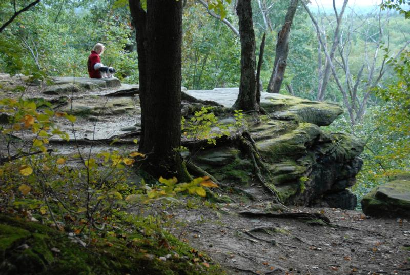
Cuyahoga Valley National Park (CVNP) spans an area of 33,000 acres. Twenty-two miles of the Cuyahoga River wind and weave through the Cuyahoga Valley, forming the backbone of CNVP. The river, with its associated riparian habitat, is just one element of the park’s habitat mosaic. From deciduous mixed-mesophytic forests to wetland habitats, from currently cultivated agricultural lands to older field habitats in various stages of succession, the park’s habitats provide opportunities for plants and animals to flourish. Over 900 plant species are found in the park, as well as 194 species of birds, 91 aquatic macroinvertebrates, 43 fish, 32 mammals, 22 amphibians, and 20 species of reptiles. CVNP contains a truly unique physical environment, formed by the mingling of two diverse geographic regions—the Appalachian Plateau and the Central Lowlands—modified by the comings and goings of multiple glaciations. High above the Cuyahoga River, the landscape is rugged, with steep-sided valleys backed by high, narrow hills. Closely spaced ravines funnel tributaries, some of which drop up to 600 feet in a distance of only a few miles, toward the crooked river. CVNP stretches into Walton Hills in the Tinker’s Creek watershed. For more information, please click the button below.
State Parks
Tinker's Creek State Park
Tinker’s Creek State Park is 355 acres of swamps and marshlands with a 15-acre spring-fed lake. This park is located at 10303 Aurora-Hudson Road in Streetsboro but extends into Aurora. The majority of Tinkers Creek State Park is maintained in its original state as a swamp and marshland. These wetlands owe their existence to the glaciers that invaded Ohio during the Pleistocene Ice Age. Glacial features include moraines, kames and eskers. Moraines were formed when a glacier remained stationary for a long period of time leaving hills of boulders, sand and gravel. Kames are deposits of sand and gravel that fell through holes in the ice leaving circular hills. Eskers are deposits of sand and gravel that dropped through ice tunnels leaving long serpentine mounds. Many fine examples of these glacial features are found in the region. This park has four trails. For more information, click the button below.
State Nature Preserves
Alice and George Gott Fen State Nature Preserve
Located in Streetsboro, the Alice and George Gott Fen State Nature Preserve is one of the finest boreal fens in the state. This 45.9 acre preservation is home to at least 18 state-listed plant species, including white wand-lily (Zigadenus elegans), fen cottongrass (Eriophorum viridicarinatum), babyberry (Myrica pensylvanica) and tamarack (Larix laricina). Gott Fen is one of only two known sites for bayberry in Ohio and the most western location for this species in the United States. The preserve is named in honor of Alice and George Gott who donated the original 14 acres to the Division in 1982. Due to the sensitivity of the fen community, access is by permit from the Ohio Division of Natural Areas and Preserves. To learn more about the Alice and George Gott Fen State Nature Preserve, please click on the button below.
Tinker's Creek State Nature Preserve
Tinkers Creek State Nature Preserve lies amid thousands of acres of rich peat, swamp and marshland. The nearly 786-acre preserve teems with a great diversity of plant and animal life. Nesting waterfowl and songbirds may be seen during the spring and early summer. Canada geese and wood ducks nest throughout the marshes and can be seen from the trails around the Seven Ponds area. Beaver ponds dot the preserve and add to the diversity of plant and animal life by providing habitat for greater numbers of species. Whitetail deer, raccoon, mink, weasel, muskrat and fox are some of the mammals frequently spotted along the trails. Among the reptiles and amphibians present are snapping turtles, water snakes, four-toed salamanders and bullfrogs. Even though it is located near a large metropolitan region, the Tinkers Creek area has remained isolated from development and retains much of its pristine charm and, natural integrity. This preservation is located at 1230 Old Mill Road in Aurora. To learn more about the Tinker’s Creek State Nature Preserve, please click the button below.
Aurora Sanctuary State Nature Preserve
Nature Conservancy Preserves
J. Arthur Herrick Fen Nature Preserve
Streetsboro is home to the J. Arthur Herrick Fen Nature Preserve. The Herrick Fen Preserve features unique geologic, hydrologic, biologic, and physical features that resulted from the retreat of glaciers during the last ice age, some 12,000 to 14,000 years ago. The preserve hosts two special fen communities, owing their presence to an impermeable silt and clay layer covered with glacial gravel that allows for the rise of cold, calcium and magnesium rich springs. The tamarack fen is the only native conifer in Ohio that sheds its needles each year, and the preserve boasts one of the few reproducing populations of it in the state. The initial preserve tract was purchased by Dr. J. Arthur Herrick in 1969 and now comprises some 140 acres. It is jointly owned by The Nature Conservancy and Kent State University, and managed by the Conservancy as a dedicated state nature preserve. To learn more about this preservation, click on the button below.
Cleveland Metroparks
Bedford Reservation
Located in Bedford, Bedford Heights, Oakwood, Valley View and Walton Hills, Bedford Reservation gives the appearance of a continuous forest of large trees and challenging terrain, which helped discouraged early logging operations. The reservation offers trails and picnic areas, and includes Shawnee Hills Golf Course as one of its attractions. Flowing through Bedford Reservation is Tinker’s Creek, named for a member of Moses Cleveland’s surveying party. The stream drops a dramatic 220 feet over a course of two miles and has cut a steep, walled gorge. The gorge, declared a National Natural Landmark, is a unique area with numerous tree, shrub and flower species. Tinker’s Creek Gorge Scenic Overlook on Gorge Parkway offers a spectacular vista particularly in the fall. To learn more about this reservation, please click the button below.
Ohio and Erie Canal Reservation
The Ohio & Erie Canal Reservation stretches through the villages of Cuyahoga Heights and Valley View and other surrounding communities. The reservation follows a portion of its namesake, the historic 309-mile Ohio and Erie Canal. Together with the Cuyahoga River, the northernmost remaining 4.4 miles of watered canal provides wildlife management areas, fishing opportunities and scenic beauty. Picnicking, hiking trails, a 7.2-mile All Purpose Trail, and unique natural and cultural heritage of this valley are also featured in this reservation. Observation decks and viewing areas provide exciting opportunities to see and hear red-tailed hawks, great blue heron, beavers, deer, orioles, yellow warblers, and other wildlife that abound in the bottomland habitat. Rich in history, the 110-mile Ohio & Erie Canal Corridor extends between Cleveland and Dover. To learn more about the Ohio & Erie Canal Reservation, please click on the button below.
Summit Metro Parks
Wood Hollow
Summit Metro Parks Wood Hollow is located at 2121 Barlow Road in Hudson. This park was made possible by a generous, unexpected gift of 150 acres. Today, the park covers just over 300 acres and includes Downy Loop Trail. This 1.2 mile trail travels mostly through beech-maple woods before entering an open meadow, crossing the entrance drive and returning to the parking lot. Boardwalks and several bridges enable users to traverse wet areas. To learn more about Wood Hollow Metro Park, please click on the button below.
Liberty Park
Summit County Metro Parks Liberty Park extends into Reminderville, Twinsburg Township, and the City of Twinsburg. This 3,000 acre park features the Liberty Park Nature Center, Twinsburg Ledges, Pond Brook Conservation Area, Tinker’s Creek Area, Tinker’s Creek State Nature Preserve, and the Recreation Area with baseball and softball fields. The reservation has several trails and harbors countless rare and endangered species, including Indiana bats, marsh wrens, and bald eagles. To learn more about Liberty Park, please click on the button below.
Geauga Park District
Beartown Lakes Reservation
Frohring Meadows
Frohring Meadows is another Geauga Park District reservation located at 16780 Savage Road in Bainbridge Township. Frohring Meadows is 298-acre park in Bainbridge Township that features a 100-acre prairie, and trails through the woodland. In the midst of the prairie is the Katydid Shelter, which provides a picnic area that will seat up to 49 people, with a nearby restroom and 40-car parking lot. This park includes 3.5 miles of trails for hiking. For more information about Frohring Meadows, please click on the button below.
Trails
Hudson/Judson Hike and Bike Trail
Franklin Township has built four miles of asphalt paved bike/walk paths adjacent to existing roads in an effort to promote an environmentally friendly community, create recreational facilities for residents, and provide safe connecting pathways. The Hudson/Judson Hike and Bike Trail stretches 1.25 miles from Spell Road to Hudson Road north of Kent. Funded by a Clean Ohio Trail grant, Franklin Township, and Ohio Department of Transportation, this trail provides a new link into Summit and Cuyahoga Counties. For more information about this trail, please click on the button below.
Portage Hike and Bike Trail
The Portage Hike and Bike Trail serves as a key east-west link between the major trail systems in Northeast Ohio. It was developed through a partnership between Portage Park District, Portage County, Wheeling & Lake Erie Railroad, City of Kent, Kent State University, Franklin and Ravenna Townships, and the city of Ravenna. Direct and indirect connections to adjacent regional trails, such as Metroparks, Serving Summit County’s Bike and Hike Trail, encourage a variety of short and long trail rides to local neighborhoods and towns to Cleveland, Akron and the Cuyahoga Valley Towpath Trail. Trail development was made possible thanks to a variety of individual donations, local, state and federal grants and through the cooperation of the ODOT and AMATS. For more information about the Portage Hike and Bike Trail, please click on the button below.
Portz Parkway Walking/Fitness Trail
The Village of Sugar Bush Knolls has two lakes, Lake Martin and Lake Roger. Both lakes are restricted to Village residents and their guests only. Removal of bass from the lakes is prohibited, but residents can kayak in these lakes. For more information about these lakes, please click on the image above.
The City of Solon has a trail, the Portz Parkway Walking/Fitness Trail. This walking path has 4 fitness structures on it and creates a scenic path to Community Park. For more information about the Community Park and Portz Parkway Walking/Fitness Trail, please click the button below.
Hudson Springs Lake
Hudson Springs Park features the 50-acre Hudson Springs Lake. This lake is home to bass, bluegill, ducks, geese, fox, deer, herons, owls, and hawks among other animals. Surrounding the lake is a meadow and woods. For more information on Hudson Springs Lake, please click the button below.
[vc_text_separator title=”Lake Martin and Lake Roger” i_icon_fontawesome=”fa fa-anchor” add_icon=”true”][vc_single_image image=”1238″ img_size=”medium” alignment=”center” onclick=”custom_link” img_link_target=”_blank” link=”http://sugarbushknollsohio.org/?page_id=405″][vc_column_text]The Village of Sugar Bush Knolls has two lakes, Lake Martin and Lake Roger. Both lakes are restricted to Village residents and their guests only. Removal of bass from the lakes is prohibited, but residents can kayak in these lakes. For more information about these lakes, please click on the image above.
[vc_tab title=”Community Gardens” tab_id=”1484229911699-9-10″][vc_text_separator title=”Twinsburg Township Community Garden” i_icon_fontawesome=”fa fa-pagelines” i_color=”green” add_icon=”true”][vc_single_image image=”1236″ img_size=”medium” alignment=”center” onclick=”custom_link” img_link_target=”_blank” link=”http://www.twinsburgtwp.com/Communitygarden.aspx”]
Twinsburg Township Community Garden Program began in 2011 as a way to provide garden plot opportunities for Township residents. The Board of Trustees subsequently re-authorized the Program in 2012, 2013, 2014, and 2015. As part of the Program, the Township prepares the land, accepts and reviews applications, and assigns plots via a random plot lottery, with a 2015 limit of up to one plot per Township household. A second garden has been established as the Twinsburg Heights Community Park, located at the east side of Rugby, south side of Eton, west side of Hadden, and the North side of Buchtel. This new garden has 22 plots ranging from 10F x 10F to 20F x 20F in size. Please click on the image above to learn more about the Twinsburg Township Community Garden.
[vc_text_separator title=”Reminderville Community Garden” i_icon_fontawesome=”fa fa-pagelines” i_color=”green” add_icon=”true”][vc_single_image image=”1237″ img_size=”medium” alignment=”center” onclick=”custom_link” img_link_target=”_blank” link=”http://reminderville.com/residential-services/community-garden/”]
The Village of Reminderville has a community garden in which residents can rent out a plot to grow vegetables and flowers. The Service Department tills the earth, but the residents are responsible for all maintenance and upkeep of their plot. The use of any fertilizer, pesticides, or other chemicals is strictly prohibited here. For more information about the Reminderville Community Garden, please click on the above image.[/vc_column_text][vc_text_separator title=”Orange Village Community Garden” i_icon_fontawesome=”fa fa-pagelines” i_color=”green” add_icon=”true”][vc_single_image source=”external_link” alignment=”center” onclick=”custom_link” img_link_target=”_blank” custom_src=”http://www.orangevillage.com/new/wp-content/uploads/2015/08/garden.png” caption=”Orange Village Community Garden” link=”http://www.orangevillage.com/community.garden.html”][vc_column_text]Orange Village owns a community garden comprised of 60 raised beds in a fenced-in area. Residents can rent a plot in this garden for$25 each year. For more information about this garden, please click on the above image.[/vc_column_text][/vc_tab][vc_tab title=”Other Natural Areas” tab_id=”1484229935641-11-8″][vc_text_separator title=”Pitluk Nature Preserve” i_icon_fontawesome=”fa fa-leaf” i_color=”green” add_icon=”true”][vc_single_image image=”1234″ img_size=”medium” alignment=”center” onclick=”custom_link” img_link_target=”_blank” link=”http://www.northfieldvillage-oh.gov/recreation.htm”][vc_column_text]Pitluk Preserve is located next to the Cuyahoga Valley National Recreation Park in the heart of Northfield Village. The preservation has trees, a stream, a ravine, wildflowers, and natural forest cover. Within a short distance from the site, pedestrians have easy access to a park in neighboring Sagamore Hills, which in turn leads them into the Cuyahoga Valley National Park. Phase I of the project has been completed, and Phase II will begin this spring. The Village plans to purchase an ATV to be used for patrolling the Pitluk Preserve and other Village parks. The Pitluk Preserve 11-acre property was donated by Sally Pitluk during Charles A. Greenlees term as Mayor (1984 – 1989). The park was named after the Pitluk family. More information about this preserve can be found by clicking on the image above.[/vc_column_text][vc_text_separator title=”Moebius Nature Center” i_icon_fontawesome=”fa fa-leaf” i_color=”green” add_icon=”true”][vc_single_image image=”1235″ img_size=”medium” alignment=”center” onclick=”custom_link” img_link_target=”_blank” link=”http://www.mymnc.org/index.php”][vc_column_text]Moebius Nature Center is a 44-acre property on E. Mennonite Road with over 40 acres of woodlands. This preservation is only open to the public when events are happening. Upkeep is handled by the Aurora Conservation Council. More information about the Nature Center can be found by clicking on the image above.[/vc_column_text][/vc_tab][/vc_tour][/vc_column][/vc_row][vc_row][vc_column]
| Park: | Address: |
| Aurora Wetlands | West Garfield Road |
| Bicentennial Park | 115 E. Pioneer Trail |
| Bretschneider Park | 881 E. Pioneer Trail |
| Former Aurora Golf Course | 159 Trails End |
| Kiwanis-Moore Park | 35 W. Pioneer Trail |
| Liz Strahan Park | 975 California Street |
| Picnic Lake Park | 1081 E. Boulevard |
| Sheldon Park | 327 Greenbriar Drive |
| Spring Hill Park | 1113 E. Pioneer Trail |
| Sunny Lake Park | 885 E. Mennonite Road |
| Veterans Memorial Park | 40 W. Garfield Road |
[/vc_column_text][/vc_tab][vc_tab title=”Bainbridge Township” tab_id=”adb436e7-a017-2″][vc_column_text]Bainbridge Township has a number of public parks that are open to the public seven days a week from dawn until dusk. These parks include athletic fields, passive park areas, and indoor meeting facilities providing a multitude of recreational opportunities to the public. Centerville Mills Park has a parking lot with permeable pavers near the Dining Hall, a project made possible by the assistance of Chagrin River Watershed Partners and funds from an Ohio Environmental Protection Agency (EPA) Section 319 grant.
| Park: | Address: |
| Centerville Mills | 8558 Crackel Road, Chagrin Falls, OH 44023 |
| Settlers Park | 17800 Haskins Road, Chagrin Falls, OH 44023 |
| River Road Park | 17535 Chagrin River Road, Chagrin Falls, OH 44023 |
| Heritage Park | 17870 Chillicothe Road, Chagrin Falls, OH 44023 |
[/vc_column_text][/vc_tab][vc_tab title=”Beachwood” tab_id=”1484249647497-3-8″][vc_column_text]Beachwood City Park West has 1.6 miles of trails on which citizens can bike, walk, run, skate, hike, and sled. The main entrances to the park are located on Richmond Road, and two minor entry points are located on East and West Shaker Boulevard.
Beachwood City Park East has one mile of paved trails with an entrance point at Shaker Boulevard.[/vc_column_text][/vc_tab][vc_tab title=”Bedford” tab_id=”1484249594528-2-10″][vc_column_text]The City of Bedford owns several parks, including Archibald Willard, Taft, Greencroft, Interstate, Tinker’s Creek, and Viaduct Parks. The Great Falls of Tinker’s Creek are located in Viaduct Park.[/vc_column_text][/vc_tab][vc_tab title=”Bedford Heights” tab_id=”1484249680206-4-5″][vc_column_text]The City of Bedford Heights owns the Lucille Reed Park at 24780 Eldridge Boulevard. This 22-acre park has a large pavilion, a tennis court, basketball courts, a sand volleyball court, a “Tot Lot” playground, tether ball, a playground structure, and restroom facilities as well as an outdoor municipal pool.
In addition, the City owns the Metro Estates Neighborhood Park at 6634 Basswood Drive. This park is 25 acres of greenspace in the middle of the Metro Estates community. This park has two large pavilions, a children’s basketball court, a large basketball court, a tot lot, a playground structure, and large open greenspace.[/vc_column_text][/vc_tab][vc_tab title=”Franklin Township” tab_id=”1484249779361-5-8″][vc_column_text]Phillips Park is located on the north end of the Township at 1119 Ravenna Road. This park is home to 6 tennis courts, a soccer field, a picnic pavilion, and a new playground.
Chase Park is located on 10 acres of beautiful land at 5891 Rhodes Road in Kent. This park is home to newly installed Gametime playground equipment, a basketball court, gazebo, a handicapped accessible ParCourse fitness course, a pavilion with picnic tables, open sports field, and a wooden walkway over a natural water outlet.[/vc_column_text][/vc_tab][vc_tab title=”Glenwillow” tab_id=”1484249822150-6-4″][vc_column_text]The Village of Glenwillow owns a number of community parks, including the Donald Norman Payne Recreation Complex, Glenwillow Community Park, John D. Brown Multi-Purpose Trail, and Glenwillow Village Center with Avery Lake.
The Donald Norman Payne Recreation Complex sits at the northwest corner of Austin Powder Drive and Pettibone Road. This 15-acre park was developed as part of the Village of Glenwillow’s agreement with the landfill operator now doing business as Republic Waste. The Donald Norman Payne Recreation Complex includes soccer fields, ball diamonds, parking, a pavilion, and the Building Department with additional vacant land to the west of the complex across Tinker’s Creek.
The Glenwillow Community Park is located on the south side of Pettibone Road west of Pinecrest Lane. This 38-acre park was purchased in 1981 with the assistance of Cuyahoga County Community Development funds and remains mostly undeveloped with the exception of a parking lot and picnic shelter.
The Pettibone Multi-Purpose Trail was renamed to the John D. Brown Multi-Purpose Trail after the Village’s Law Director following his retirement in 2010. This trail begins at the north side of Pettibone Road from Austin Powder Drive and extends to Richmond Road. The construction of this trail was aided by funds from the Ohio Department of Natural Resources Community Development Block Grant awarded by the Cuyahoga County Board of Commissioners and the Village of Glenwillow. 10 feet wide with asphalt paving, this trail is used extensively by residents for walking, jogging, and riding bikes. This trial also connects with the Oakwood Village and Cleveland Metroparks trail systems.
Constructed in 2005, the Glenwillow Village Center combines the “old company town” heritage of the village with the need for new residential and commercial buildings through its four components: Retail including a Restaurant, New Residential Units, and Renovated Residential and Professional Homes. Part of this project was the Village Park and creation of Avery Lake. The Village Park includes walking trails from Austin Powder Drive east around the lake to Shops and Glenwillow Grille on Pettibone Road. A modern gazebo in front of the lake serves as an entertainment venue for community concerts, gatherings, and art shows.[/vc_column_text][/vc_tab][vc_tab title=”Hudson” tab_id=”1484249875820-7-9″][vc_column_text]The City of Hudson owns 20 parks, offering 1128 acres of active and passive recreation, conservation, and preservation. Fishing is available at Hudson Springs Park and Barlow Farms Park, boating at Hudson Springs Park, community gardens at Barlow Farm Park, and a variety of other recreational activities like baseball and volleyball at the remaining parks.
| Park: | Address: |
| Barlow Farm Park | 1965 Barlow Road |
| Bicentennial Woods | 2302 Victoria Parkway |
| Boston Mills Park | 505 Boston Mills Road |
| Cascade Park | 130 Lynn Drive |
| Colony Park | 6075 Ogilby Drive |
| Darrow Road Park | 7303 Darrow Road |
| DiNovi Park | Abbyshire Drive |
| Doc’s Woods | 5769 Stow Road |
| High Point Park | 3100 Middleton Road |
| Hudson Springs Park | 7095 Stow Road |
| MacLaren Woods | 90 John Clark Lane |
| Maple Grove Park | 934 Farnham Way |
| Middleton Park | 1738 Middleton Road |
| Oak Grove Park | 2200 Barlow Road |
| Robinson Field | 2600 Ravenna Road |
| Nicholson Trail | Nicholson Drive |
| Trumbull Woods | 3200 Middleton Road |
| Turnpike Trail | Stow Road |
| Veterans Way Park | 55 Veterans Way |
| Wildlife Woods | Boston Mills Road |
[/vc_column_text][/vc_tab][vc_tab title=”Macedonia” tab_id=”1484249916750-8-7″][vc_column_text]The City of Macedonia Family Recreation Center is a 55,000 ft2 community and fitness center located at 1494 East Aurora Road. This facility is located on the City of Macedonia’s park with pavilions, baseball fields, restroom facilities, and more. Lake Macedonia is also located at this facility.[/vc_column_text][/vc_tab][vc_tab title=”Maple Heights” tab_id=”1484250065004-11-3″][vc_column_text]Stafford Park in Maple Heights is centrally located at 5400 Mayville Avenue. This park has 3 large pavilions, tennis courts, basketball courts, and ball diamonds. In addition, Stafford Park has over 35 acres of natural woods, picnic areas, playground, grills, and greenspace.
Dunham Park features over 20 acres of woods and greenspace with 2 pavilions, playground equipment, a football field, and a ballfield. This park is located on the western edge of Maple Heights at 15005 Schreiber.
Benhoff Park is located off of Dunham Road. It was a one-time home to Maple Heights Youth Baseball and Soccer leagues. This park also has a playground and large parking lot.
Southgate Park is a 1-acre neighborhood park located between Edgewood and Northwood Avenues. The park has benches, a swing set, a slide, and several other playground amenities.
Home Street (Cunwillow) Park is located off Garden and Home Streets. This park features a large field, benches, a playground with a swing set and slide, and basketball courts. This neighborhood park does not have a parking lot and closes at 8 PM.
DARE Park is located on Friend Avenue and can be accessed from either the backside of the County Library or from Friend Avenue. It is a smaller neighborhood park with swing sets, a merry-go-round, and a jungle gym. This park closes at 8 PM.[/vc_column_text][/vc_tab][vc_tab title=”Northfield” tab_id=”1484249955785-9-7″][vc_column_text]The City of Northfield owns two parks and one nature preserve: Huntington Park, Smith Park, and Pitluk Preserve.
Located on Magnolia Avenue, Huntington Park is a 2.2 acre park with a baseball field, basketball courts, a playground, and picnic tables. This park was named after Fire Chief Donald Huntington.
Smith Park on Houghton Road was named after Mayor Jerome B. Smith. This 3.5-acre park features a baseball field, basketball courts, a playground, and picnic tables.[/vc_column_text][/vc_tab][vc_tab title=”Oakwood” tab_id=”1484250026295-10-8″][vc_column_text]The Village of Oakwood owns and maintains one community park, Oakwood Community Park.[/vc_column_text][/vc_tab][vc_tab title=”Orange” tab_id=”1484250129022-12-0″][vc_column_text]The Orange Village Community Park spans an area of over 60 acres. Orange Village was awarded a Natureworks grant in 1998 to construct an additional mile of paved nature trail, install fitness stations, and build three informational kiosks. The park now has 1.5 miles of trails, over 60 acres of woodlands and park space, playgrounds on White Drive and Pike Drive, two baseball fields, a soccer field, putting greens, chipping greens, a sand volleyball court, a sledding court, two picnic pavilions, a gazebo, an amphitheater, the community garden, a basketball court, and a volleyball court.
Orange Village also has a dog park that is open every day from dawn to dusk. The park has a separate area for small dogs as well as rules and regulations.
Reminderville
The Village owns Ray Williams Park, located on Glenwood Boulevard next to the Service Department. This park includes a picnic pavilion with tables and electrical outlets, playground equipment, and plenty of open space for games. Gazebo Park is another Village park with open space for picnics, reading, or other activities.
Solon
The Solon Community Park has many different aspects of outdoor activities for residents to indulge in. The park is located at 6679 SOM Center Road across from the Solon Public Library. 10 widely spread baseball fields are located at the Community Park and games are played every weekday. A concession stand is open during game hours. In the middle of the field are two separate playground areas and large pavilion.
Timberlake Park is a more private area in Solon for people to gather under the pavilions, play on the playground, and play in the wide open playing areas. The park is located off of Root Road in Bainbridge. Timberlake Park also has an approximately 4-acre lake stocked with bluegill, bass, catfish, and sunfish. Fishing is permitted in this lake. The park is closed November 1 – March 1 each year.
Solon is also home to outdoor basketball courts, outdoor tennis courts, and “Little Fields Playground.
Streetsboro
The City of Streetsboro owns Streetsboro City Park, a 116 acre park with 9 baseball or softball diamonds, 1 basketball court, 2 tennis courts, 2 restroom facilities, a concessions area, pavilion, skate park, maintenance building, new playground, walking trail, and open space. In 2013, the Streetsboro Parks and Recreation Department were recipients of the 19th round of Ohio Department of Natural Resources NatureWorks Grant. This grant funded new additions to the playground including a climbable pup tent, rock tunnel, and 2-5 year old play structure.
Wilcox Memorial Park is located north of U.S. Route 303 and west of Route 43. The park consists of playgrounds for children ages 2-5 and 5-12. Numerous natural resources are present at this 22-acre site including floodplain and wetland areas, a tributary of Tinker’s Creek, and upland hillsides.
The Thomas Heritage Park is located north of U.S. Route 303 and west of Route 43. The focal point of this 108-acre park is a newly developed dog park with areas for “large” and “small” dogs. Other park amenities include a fishing deck, fishing pond, walking paths, and gravel parking area.
Twinsburg
The City of Twinsburg owns five (5) parks with amenities such as playgrounds, ball fields, basketball courts, soccer fields, trails, shelters, grills, and tennis courts. Each park includes at least one of the following trails: Birchwood Trail, Liberty North Trail, Liberty South Trail, Tree Sparrow Trail, Old Hickory Trail, and Central Valley Trail.
| Park: | Address: |
| Glenn Chamberlain Park | 10260 Ravenna Road |
| Birchwood Park | End of Ashdale Drive and White Oak Drive |
| Liberty Park | 9385 Liberty Road |
| Glenmeadow Park | 1957 Glenwood Drive |
| East Idlewood Park | 9797 East Idlewood Drive |
Twinsburg Township
Twinsburg Township Square, known alternately as the Park, is located at the intersection of Darrow Road (SR 91) and East Aurora Road (SR 82). Originally six acres in area, the parcel on which the Square is located measures just over three acres today. The parcel includes a parking lot maintained by the Township on the Square’s north side. The Square was deeded to the Township in the early 1800’s by Moses and Aaron Wilcox. Since that time the Square has undergone many changes, with today’s improvements including a stage, several monuments and memorial features, a network of sidewalks, decorative lighting, picnic tables, and a constantly changing family of trees. On-street parking is available on Church Street west of the Square.
A.W. Robertson Park is located at the intersection of Twinsburg Road and Katz Road. Robertson Park measures 2.29 acres in size and was deeded to the Township in the late 1950’s by developers of the adjacent Mar-Well Estates Allotment. The Park was named after a Township resident who lost his life in the Vietnam War. The Township obtained grant funding to install a paved path and parking area on this parcel in 2007, with other current improvements including a gazebo and picnic tables. The Township installed playground equipment and additional north of Katz Road adjacent to the Park in late 2008. On-street parking is available on Katz Road north of Robertson Park.
Erwin Geis Park is located along Bavaria Road, south of Enterprise Parkway in the Township’s industrial area, also known as the Joint Economic Development District (JEDD) area. The Park measures 5.03 acres in area and includes a large pond that also serves as part of the industrial park’s storm water management system. Erwin Geis Park was deeded to the Township in the late 1990’s by developers of the Twinsburg Industrial Park, and the Board of Trustees named the Park after the late Erwin Geis, developer of the Twinsburg Industrial Park and many other thriving areas throughout Northeast Ohio. The Township teamed with the Geis family and the Township’s JEDD partner, the Village of Reminderville, to install a pergola, sitting area, landscaping, memorial stone, and flag pole, along with a nearly quarter-mile concrete walking path and benches. A dedication ceremony, with members of the Geis family present, was held in late 2005 for the Park upon completion of initial improvements. On-street parking near the Park is limited, but Erwin Geis Park is completely accessible via the JEDD area’s recently constructed sidewalk network.
Twinsburg Heights Community Park is centrally located in the Twinsburg Heights neighborhood. The Park measures 2.71 acres in area and includes playground equipment, paths, picnic tables, and a community garden. Twinsburg Heights Community Park was acquired by the Township through fee simple purchases of three separate parcels in 2011, 2013, and 2014, respectively. The Township sought and obtained grant funding to defray the cost of 2015 improvements to the property, with a dedication ceremony to be held in early 2016 for the Park upon completion of initial improvements. There is ample on-street parking near the Park, with additional off-street parking contemplated in future years.[/vc_column_text][/vc_tab]
Valley View
The Village of Valley View owns three municipal parks: Valley View Woods, Lombardo Park, and Miller Park.
Valley View Woods is located at 13005 Schreiber Road and has walking trails, two baseball/softball fields, two playgrounds, five picnic pavilions, basketball court and tennis courts, two sand volleyball courts, horseshoe pits, bocce ball courts, and a gazebo.
Lombardo Park is located at 9736 Charles Drive and has a picnic pavilion, a baseball/softball field, a tennis court, basketball court, and a playground.
Miller Park, otherwise known as “Tiny Lane”, connects Murray and Fosdick Roads. Residents can enjoy a picnic pavilion, basketball court, and a playground.
Warrensville Heights
The City of Warrensville Heights is home to Green Park. Located at 4501 Green Road north of Emery Road, the park features a jungle gym, slides, and swings for young children as well as a gazebo and picnic area for residents. The park is open daily from 8:00 a.m. to dusk in the warmer months and closes for the season on December 1.